Geographic Information Systems (GIS) are a useful investigation technique, employed in botany for mapping, cataloging, and analyzing the distribution of plants, as well as understanding and monitoring their spatial and temporal dynamics. GIS is particularly valuable not only for research and study of plants in their natural environments but also for managing trees in urban settings. Accurate knowledge of trees in cities is essential for conducting surveys as required by governmental and supranational guidelines. The capability of GIS to associate virtually infinite information with mapped elements forms the basis for proper management and mitigation of risks associated with the presence of tall, monumental, or aging trees. A georeferenced catalog of trees enables an assessment of economic resources to allocate to their maintenance, which is a crucial element in formulating a budget for a public administration.
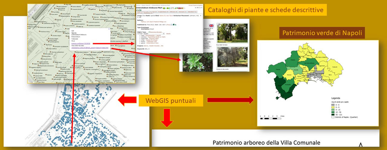
The botanical garden employs GIS to catalog its plant heritage, and this approach has been extended to other areas of the city within the frame of the Garden’s research activities. Furthermore, utilizing a recent evolution of this technique, namely WebGIS, the Botanical Garden provides online tools to discover the plant species cultivated in the garden and in the city of Naples.
Some of our activities:
- The tree heritage of the Botanical Garden of Naples
An application to discover the over 1900 trees growing in the Garden. - The evolution of the of the Botanical Garden of Naples, an application to observe the changes occurred in the Garden from 1818 to present through historical maps.
- The City Garden (“Villa Comunale”) in Naples and its tree heritage.
- The green component of the city of Naples: an application that illustrates the availability of urban green areas, neighborhood by neighborhood, in the city of Naples, with a detailed mapping of all types of urban green areas, also in relation to the subway stations present in the city.
- The Garden of the Five Continents at the University of Suor Orsola Benincasa
Through the collaboration between the University of Naples Federico II and the University of Naples Suor Orsola Benincasa, within the projects of Cultural Heritage and Architecture, the mapping of the "Garden of the Five Continents" located at the historical headquarters of Suor Orsola is currently being carried out. Botanical knowledge and historical-artistic research come together to create a WebGIS application where plants are no longer just botanical entities but also Naturalia, objects of a naturalistic, historical, and artistic museum path. Work in progress.
Literature
Amoroso. S., Menale B., Sibilio G. 2021 [2022]. La gestione del Patrimonio verde delle città antiche: un censimento geo-referito per l’analisi spazio-temporale della composizione floristica della Villa Comunale di Napoli, pp. 105-128. In: GIS DAY 2021. Il GIS per il governo e la gestione del Territorio (a cura di Barbara Cardone, Ferdinando di Martino). Roma: Aracne editrice.
Bottigliero M. V., Sibilio G., Caputo P. 2020. Un catalogo Gis-Oriented per la gestione del patrimonio arboreo degli Orti Botanici: l'esempio dell'Orto Botanico di Napoli, pp. 123-142. In GIS DAY 2020. Il GIS per il governo e la gestione del Territorio (a cura di Barbara Cardone, Ferdinando di Martino e Salvatore Sessa). Roma: Aracne Editrice.
Sibilio G., Muoio R., Menale B., Caputo P. 2019. The “Green Component” of Naples, pp. 145-172. In GIS DAY 2019. Il GIS per il governo e la gestione del Territorio (a cura di Barbara Cardone, Ferdinando di Martino e Salvatore Sessa). Roma: Aracne Editrice.
Sibilio G., Muoio R., Menale B., Caputo P. 2017. Open Web Mapping (WebGIS) for the Description and Historical Analysis of the Exhibition areas of the Botanical Garden of Naples, pp. 23-35. In GIS DAY 2017. Il GIS per il governo e la gestione del Territorio (a cura di Salvatore Sessa, Ferdinando di Martino e Barbara Cardone). Roma: Aracne Editrice.
Sibilio G., Muoio R., Menale B. 2016. The Geographic Information Systems (GIS) for management and analysis of ethnobotanical heritage of an area at high volcanic risk: the Vesuvius National Park (Campania, Southern Italy), pp. 47-61 in: GISDAY 2016. Il GIS per il governo e la gestione del Territorio (a cura di Ferdinando Di Martino, Barbara Cardone e Salvatore Sessa). Roma: Aracne Editrice.